-
We are writing to announce an important update regarding how we distribute our bulk parcel dataset. Effective in the 2026.2 release coming up in April, we will no longer be offering the Shapefile format for bulk downloads of the full dataset. We understand that this change may impact some of our users, and we want to take this opportunity to explain the reasons behind this decision and provide guidance on the alternative formats available.
Going forward, we will primarily support the Geopackage file format for bulk file downloads.
Why We Are Discontinuing Shapefile Support
Our decision to transition away from the Shapefile format is driven by technical limitations that have become increasingly difficult to manage as our parcel dataset grows. The primary factors influencing this change are:
1. File Size Limits
The sheer volume of our complete parcel data has begun to push against practical and technical constraints imposed by the Shapefile format. While individual county or small-area Shapefiles can be managed, aggregating state-level data into a single Shapefile results in extremely large file sizes. This breaks down because of the hard 8GB size limit of Shapefiles: Many states simply cannot fit into a single Shapefile because the format imposes an 8GB per-file size limit.
2. Field Length Limitations and Data Truncation
The Shapefile format has a significant limitation on the length of data that can be stored in certain fields, most notably in the DBF file component. Our parcel dataset includes detailed attributes, such as the legaldesc field, which often contains extensive, highly detailed text descriptions.
The maximum character limit for fields in the Shapefile format is causing vital information to be truncated. In cases where fields are longer than 254 characters, they are truncated in Shapefile format. For example, our export process will return a warning that looks like this:
Warning: Value '45.5AC BEG SW COR SEC 1 TH N 420 NE 695 NW 370'N 610 NE 110 SE 600 NE 1210 E 700 S 390 SW 481.05 TO E R/W MARCH ST TH SE ALG R/W 432.88 NE 133.74 TO W R/W HICKSIND BLVD TH SW ALG R/W 1009.57 NW 444 NE 858'NW 470 SW 451 NW 140 SW 1535 SE 300 NE 95'SE 360 W 718 TO POB.' of field legaldesc has been truncated to 254 characters.In the case of floating point values, we see warnings that look like this:
Value 102820483.599095315 of field calcarea of feature 2147292 not successfully written. Possibly due to too larger number with respect to field widthData integrity is our top priority. To ensure all users receive the complete, un-truncated legal descriptions and other lengthy attribute data, we must move to a more modern, robust format that can accommodate these data lengths.
Recommended Alternative Formats
We have transitioned to formats that better support large datasets and maintain data fidelity. For users who need to download the complete parcel dataset, we strongly recommend using the GeoPackage (.gpkg) format.
The GeoPackage format is an open, standards-based format that is fully supported by all major GIS software platforms (e.g., QGIS, ArcGIS). Key benefits include:
- No File Size Limits: GeoPackage is based on SQLite and can handle massive datasets without the practical size constraints of Shapefiles.
- No Data Truncation: It fully supports longer field lengths, ensuring the complete and accurate retention of information like the legaldesc field.
- Single File Structure: The entire dataset, including geometry and attributes, is stored in a single .gpkg file, making distribution and management simple.
We encourage you to update your workflows to utilize the GeoPackage format for all future bulk downloads. For more information on how to access the new file format, please refer to our Bulk Download Guide which you can find at File.
We appreciate your understanding as we continually work to improve the quality and accessibility of our data. If you have any questions or require assistance transitioning your processes, please contact our support team.
-
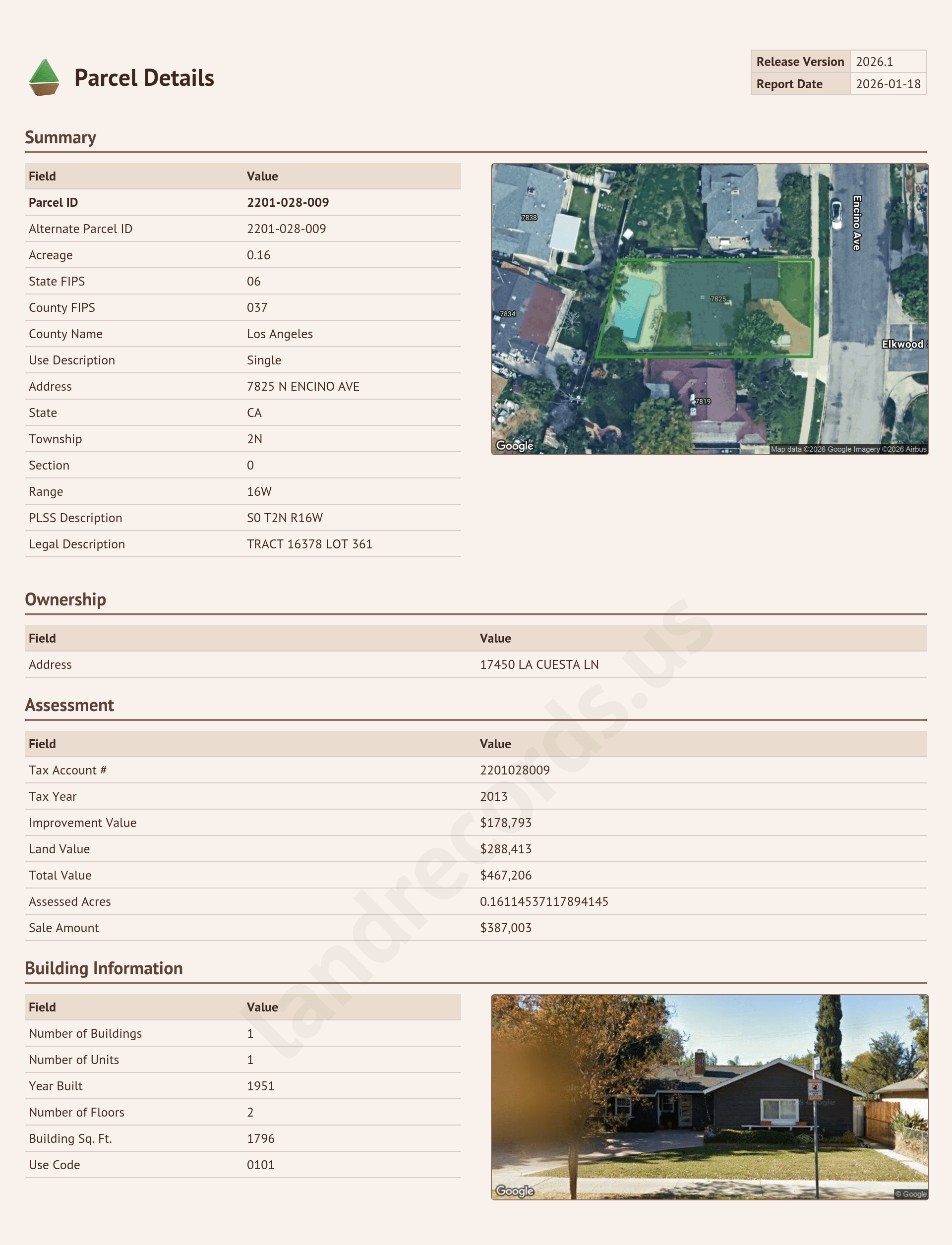
Today we’re excited to announce a new feature that allows anyone to generate a report for any parcel in the United States.
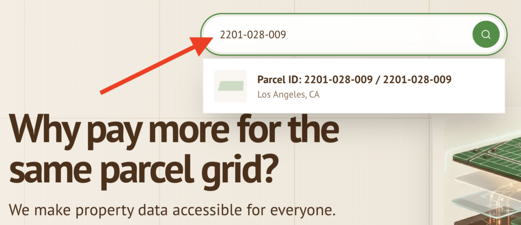
Just visit our homepage and type in the Parcel ID (also known as APN, AIN, parcel number, etc). You’ll get a dropdown of matching parcels. Sometimes you may see several options since APNs are not unique across counties — select the one you’re looking for, and get a report with additional information about that parcel.
Explore our data!
Now you can explore our parcel data using the Map Explorer at https://landrecords.us/products/us or by generating a custom report for an individual parcel.
I hope you find this useful. Happy searching!
-

* I need to charge $1.00 for the download, I’ll explain why later in this post.
Our mission is to make quality property data accessible to everyone. In keeping with this mission (and to increase awareness of this website 🙂 I want to offer our Q1 2026 Nationwide Parcel Layer for free. No strings, no nonsense, just a shameless marketing exercise that I hope will benefit my customers and the landrecords mission at the same time. I hope you’ll participate in this experiment with me!
How does this work
For the month of January 2026, click the link at the bottom of this post to buy the dataset for one dollar. After you checkout, you’ll get an email with a link to download the full dataset as a GeoPackage (.gpkg) file. That’s it. Load the data into whatever you load your geospatial data into, and let me know how it works for you.
I want feedback and insights and use cases from real people. You can send an email, or file a support ticket on your account page where the downloads are located.
Why are you charging $1.00 instead of $0.00?
Internet bandwidth and server capacity doesn’t grow on trees, and I need some way of throttling how may people are downloading the file at the same time (it’s a really big file [~100GB], the download will take awhile). I also want to make sure the data is getting in the hands of real people rather than bot farms. I will set “inventory” levels on the website based on how many downloads I can support at a time.
But why?
I want your feedback on how to improve the product. This is a way for me to
bribeincentivize my potential customers to give me information about what additional attributes, coverage, and other improvements you’d like to see in the dataset so I can prioritize effort and investment. And I would love to hear about the projects you’re working on.I will try to keep this going for as long as people are interested, and for as long as I can support it. I hope you find the data useful for your projects.
If you have any questions about this or anything else parcel-related, send me an email.
-

The year 2025 continues to be a big year for landrecords.us customers, and our Q4 release is no different! This is the last layer release of 2025.
We are thrilled to announce the release of the latest update to our flagship product: the Land Records Q4 2025 Nationwide Parcel Dataset! This will appear as 2025.4 in the
lrversionfield.This new version provides the most current and comprehensive land record information available, ensuring you have the data accuracy and coverage you need for all your projects.At Land Records, we are committed to providing timely, high-quality geospatial data. The Q4 2025 release reflects our continued effort to enhance our dataset’s coverage, accuracy, and ease of use.
What’s New in the Q4 2025 Release?
This latest version includes significant updates and improvements across the board, making it our most robust dataset yet. We’ve maintained our 99%+ parcel coverage while adding coverage for highly-requested attributes:
Expanded Attribute Coverage
We have successfully integrated new data from additional jurisdictions, further expanding our already industry-leading coverage.
- Ohio: improved ownership name and owner address coverage
- Northeast Ohio: improved zoning and landuse coverage
- Washington State: improved ownership and building appraisal attribute coverage
- Puerto Rico: we now have reached majority coverage of PR
Bug fixes
- Approximately 75 parcels on the Virginia / West Virginia border were incorrectly categorized as belonging to WV. This has been resolved.
- Travis County TX did not accurately stack related parcels. This has been resolved by joining against their authoritative appraiser data, and results in the addition of approximately 35,000 parcels to Travis County.
How to Access the Q4 2025 Dataset
Current Land Records subscribers can download the Q4 2025 update immediately through the client portal, or by contacting support: hello@landrecords.us.
If you are not yet a Land Records customer, now is the perfect time to explore the power of the most comprehensive nationwide parcel dataset on the market.
We look forward to hearing about the amazing apps you will build on top of our parcel dataset.
What are we working on next?
We will have a very special announcement in tandem with our Q4 2025 release. Many of you have asked us to make it easier to test and evaluate our dataset to determine if its the right fit for your use case. Currently we don’t have a systematic way of getting our data in the hands of non-subscribers. In early 2026, this will change. Stay tuned!